Mi 11 Mai 2016 | -- (permalink)
We are please to announce the release of GridKit 1.0 toolkit, which was developed in the context of the SciGRID project. GridKit is a power grid extraction tool which uses OpenStreetMap data.
The purpose of GridKit is to convert geographical objects representing power elements in OpenStreetMap to model the electric network. GridKit uses all power elements and not only power relations and therefore extends SciGRID capabilities by using spatial heuristic analysis. GridKit can be used to derive the power network where the power relations coverage is lacking. However, GridKit depends on the availability of power information in OSM.
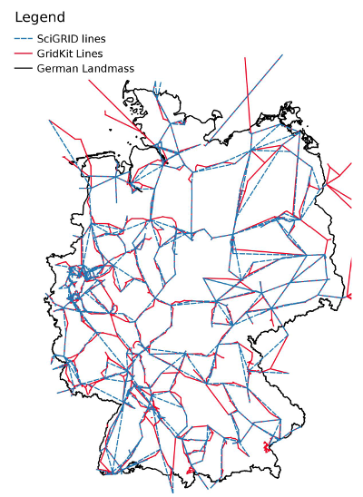
The figure below depicts the German transmission network obtained using SciGRID and GridKit (OSM data status 09.11.2015). In Germany, power relations have a very coverage and therefore the transmission network obtained by both approaches is comparable.
The GridKit code can be downloaded from the github repository. Additionally, extracts of the European and North-american high-voltage networks can be retrieved here. The output high voltage network of GridKit is contained in the tables heuristic_vertices_highvoltage and heuristic_links_highvoltage. The tables include the IDs of the vertices and links as various information (name, frequency, voltage, osm_id and type).
A detailed documentation of GridKit can be found in the Master thesis of Bart Wiegmans. A detailed user GridKit is available on the here.